A good omen for the new year? It’s a pleasure to see that our post from late last year exploring a wonderful new digital map collection at Cornell Library was recently featured by Mimi Kirk over at the Atlantic‘s City Lab. Here’s a preview, in case you missed it:
When PJ Mode began to purchase old maps in the 1980s, he set out to amass a typical collection of world maps. But along the way, his attention turned to unusual maps that dealers weren’t sure how to categorize—those that attempted to persuade rather than convey geographic information.
“Most collectors looked down their noses at these maps because they didn’t technically consider them maps,” Mode says. “But they were fun and they were inexpensive, and over the years I became more interested in them than the old world maps.”
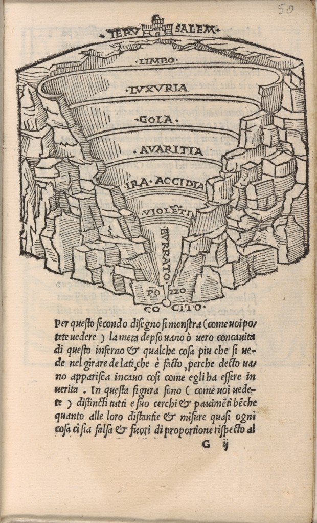
The interest has culminated in a collection of more than 800 “persuasive maps,” as they are now called, which can be found in digital form through Cornell University’s library. Mode has sorted them into themes, from imperialism to religion to slavery, many with meticulous notes about their history and meaning. One of the oldest, from a 1506 Italian manuscript, gives an overview of hell, while more recent acquisitions include a facetious 2012 New Yorker cover of the Second Avenue subway line.
An overview of hell, as seen in a 1506 Italian manuscript. (Courtesy of Cornell University—PJ Mode Collection of Persuasive Cartography)
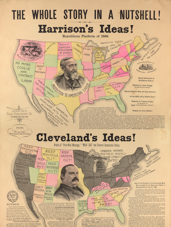
Marc-William Palen, a University of Exeter history professor and author of The “Conspiracy” of Free Trade, recently came across the collection. “I got lost in it for days,” he says. Palen, who specializes in British and American imperialism, was particularly taken with an 1888 map depicting the trade policy platforms of the year’s presidential candidates, Democratic incumbent Grover Cleveland and Republican Benjamin Harrison. While Cleveland and his party supported free trade, the Republicans’ platform was deeply protectionist.
In case you missed it (I was tweeting about it A LOT last week), Cornell Library’s Digital Collections have just made available an amazing archive – the PJ Mode Collection – consisting of around 800 political maps that should be on the radar of anyone working on imperial and global history. They. Are. Awesome.
Here’s a sampling.
‘The Whole Story in a Nutshell!’ (1888) – Here’s one of my favorites for a lot of reasons. To give it some context, the so-called Great Debate of 1888 (that year’s presidential election) was centered around the future of US trade policy. The GOP was staunchly protectionist and Anglophobic at this time, and they feared the perceived influence of ‘Free Trade England’ on US politics. British free traders (in particular London’s Cobden Club, featured on the bottom left), were the main targets of paranoid Republican protectionist propaganda. Democratic President Grover Cleveland only added to the conspiracy theories when he filled his cabinet and advisors with US members of the Cobden Club. The pro-Harrison map does a vivid job of illustrating the GOP’s economic nationalism in contrast to Democratic free trade. For more on this, my book, The ‘Conspiracy’ of Free Trade, explores the conspiratorial reception of British free-trade ideas in Gilded Age America.


You must be logged in to post a comment.