
Mitchel Stuffers
Assistant Editor at CIGH Exeter & PhD Candidate in History, University of Exeter
Blog of the Centre for Imperial and Global History at the University of Exeter
Mitchel Stuffers
Assistant Editor at CIGH Exeter & PhD Candidate in History, University of Exeter
This is the fourth blog post created by students of the 2026 ‘Linguistic Landscapes‘ Summer School at Venice International University, in conjunction with the University of Exeter and KU Leuven.
Martha Targett, Yi Lu
The area we explored was the Santa Marta area of the Dosorduro district of Venice (see picture below). It is an area of Venice which is highly populated by students, and there is a large student accommodation complex associated with the Ca’ Foscari University of Venice. The area we studied is also home to various university buildings relating to Ca’ Foscari University of Venice and IUAV University of Venice. In particular, the headquarters of the IUAV University of Venice are based here and the district is also home to many of the Ca’ Foscari humanities department buildings, which means that many of the students living in this area are humanities students. In accordance with this, a lot of the graffiti, stickers and posters from this area referred to left-wing ideas and political movements. Alongside the large student population, the area is historically a working-class area, and there is lots of social housing dating from the 20th Century.
While walking around the Santa Marta area of Venice, we noticed the substantial amount of graffiti. As a result, we decided that our study of the linguistic landscape of Santa Marta would be focussed on our research relating to the graffiti we observed while investigating this urban landscape.
Continue reading “Exploring the Linguistic Landscape of Santa Marta”This is the third in a series of blog posts created by students of the 2026 ‘Linguistic Landscapes‘ Summer School at Venice International University, in conjunction with the University of Exeter and KU Leuven.
Mona Mezhoud
Public space is never neutral. As Michel Foucault argues in his influential essay on heterotopias, places are always embedded in relations that either reveal or obscure power structures: heterotopias function as counter-sites where social orders are “simultaneously represented, contested, and inverted” (Foucault, 1986 [1984]: 24). Applied to Venice, this observation can be sharpened considerably — and, as the following comparison suggests, it is not merely an external theoretical import grafted onto the case. Tufi’s own linguistic landscape study of Venice arrives independently at the same framework, describing the city’s linguistic landscape as the product of a “dislocation of (real) place and the creation of a heterotopia” (Tufi, 2017: 89), a liminal space that is “simultaneously real and unreal.” Venice is no longer an everyday living space for its residents but a site where representation, contestation, and inversion of spatial order are constantly layered on top of one another under the sign of mass tourism. As Tufi notes, “In the LL [Linguistic Landscape] of Venice’s most visited areas there is evidence that Italian is undergoing a minoritisation process and, as a result, social levelling with respect to the languages ascribed to the main tourist groups” (Tufi, 2017: 85).
Language plays a central, though often underestimated, role in this negotiation of space. Norman Fairclough showed that language is not a neutral resource but a social practice that both reflects and (re)produces power relations (Fairclough, 1989: 26) — a framework applicable directly to Venice’s linguistic landscape, from multilingual, tourist-oriented signage to official municipal announcements: decisions about who may place which language where are never merely stylistic, but are always already questions of power.
This paper examines how a specific form of linguistic dominance has taken hold in the area around Santa Maria Maggiore in Venice, one that has increasingly adapted public space to an international, English-speaking tourism economy — and how this dominance has progressively marginalized the Venetian population, prompting residents, in turn, to reclaim that same space through language.
Continue reading “Linguistic Dominance and Resistance in the Linguistic Landscape of Venice”
Mitchel Stuffers
Assistant Editor at CIGH Exeter & PhD Candidate in History, University of Exeter
This is the second in a series of blog posts created by students of the 2026 ‘Linguistic Landscapes‘ Summer School at Venice International University, in conjunction with the University of Exeter and KU Leuven.
Wout Huygens, Horace Lee & Ellie Nicholls
During the Summer School on Linguistic Landscapes in Venice, we analysed the linguistic landscape of the area around the Basilica dei Santi Giovanni e Paolo in the northern part of the main island. By adopting Lynch’s framework on the elements of the city image (Lynch, 1960), we identified the major paths, edges, districts, nodes and landmarks in the region. In this blog post, we argue that transportation has a clear effect on the linguistic landscape, that the graffiti and stickers reveal certain political tensions and that there is clear asymmetry of multilingualism in our chosen area of the city.
By following Lynch’s elements of the city (Lynch, 1960), we started by tracing the edges, which are all clearly defined waterways, as well as the waterways within our region. Next, we plotted all bridges on our map acting as a base for the paths. Then, we added the public transportation nodes and landmarks, consisting of two water bus stops for the vaporetti, a hospital, the basilica and 3 churches. After carefully analysing the linguistic landscape and the transport streams, we added the main walking paths (see Image 1).
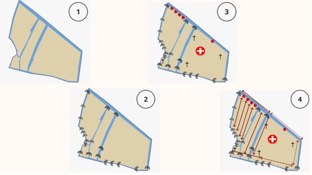
Image 1: Mapping process of the Santi Giovanni e Paolo region in Venice
Based on these data, we also divided the region into different districts (see Image 2), coinciding with Lynch’s categorization (Lynch, 1960). Districts 1 and 5 cover the waterfront areas near the touristy Fondamente Nove area and the hospital area respectively, characterized by the public transportation nodes. These districts are characterized by movement from/to a specific node within the district. Districts 2, 4, 7 and 8 each symbolize a path, characterized by pedestrian through-traffic. Instead of movement from/to a specific point within the district, this area acts as a passageway from a point outside the district to another point outside the district. Finally, districts 3, 6, 9 and 10 refer to areas around landmarks, in this case a church, the basilica or the hospital. Similar to the node districts, the movement within these districts is also oriented towards a specific point within the district, but these districts usually act as destinations as opposed to intermediate transfer points in districts 1 and 5.
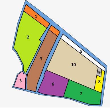
Image 2: Identified districts in the Santi Giovanni e Paolo region in Venice
Continue reading “Santi Giovanni e Paolo: a region filled with linguistic, transportation and political contrasts”
Mitchel Stuffers
Assistant Editor at CIGH Exeter & PhD Candidate in History, University of Exeter

Mitchel Stuffers
Assistant Editor at CIGH Exeter & PhD Candidate in History, University of Exeter
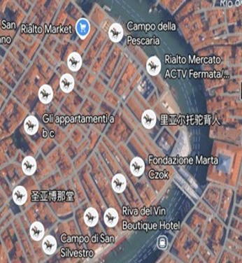
This is the first in a series of blog posts created by students of the 2026 ‘Linguistic Landscapes‘ Summer School at Venice International University, in conjunction with the University of Exeter and KU Leuven.
Karin Swahn, Shinhaz F. N. & Wenhan Kang
Space can be understood through the interrelated dimensions of perceived, conceived, and lived space (Lefebvre, 1991). Walking through the Rialto Pescheria and Beccarie area in Venice, we encountered the city primarily through the perceived dimension of space. We understood the area through what we saw, heard, and noticed through our senses. As visitors, we experienced the space without inhabiting it as part of our everyday lives and without the planner’s perspective through which urban space is conceived. Wenhan Kang, our only Italian-speaking member, was also the only one who had previously visited Venice, leaving the other two of us to encounter the area as tourists with analytical gazes.
To analyse this, we decided to frame our material through the concept of authenticity. According to Zukin (2008, 2010), authenticity has become increasingly important as a way of marketing and selling urban spaces since the 2000s. Zukin challenges the conventional idea of authenticity as something inherent, traditional, or sincere by presenting it, instead, as a quality that is socially constructed and externally recognised. It does not necessarily represent local residents and often reflects the tastes of the middle and/or upper classes. In this sense, authenticity can function as a form of power that contributes to gentrification and the displacement of an area’s original inhabitants.
What does “authentic” look like in urban spaces? According to Zukin (2008, 2010), it often appears through small shops, “ethnic” restaurants, alternative forms of lifestyle consumption, and carefully constructed narratives attached to venues or products. We know what these narratives look like: “this shop started as a dream between two friends…”, or “our cicchetti continues the fish market’s tradition of combining fresh fish, international influences and old recipes…”. Zukin (2010, p. xiii) describes such authentic spaces as using, “bits and pieces of cultural references: artfully painted graffiti on a shop window, sawdust on the floor of a music bar, an address in a gritty but not too thoroughly crime-ridden part of town.” While this description is rooted in an American context, similar authenticity markers can be found in Venice, for example in wooden signs, chalkboards, and the mixing of Italian and English.
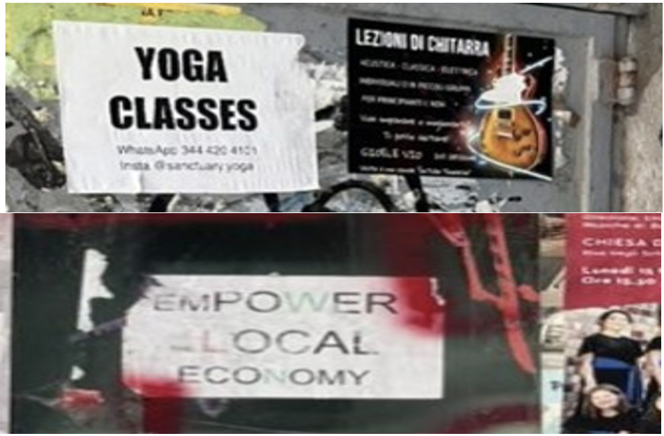
In Venice, tourists’ search for authenticity produces a space that is constantly judged by its appearance, cosmopolitan character, and performance of heritage. It creates a city of heightened representation and romanticisation, in which locals’ lived space is given very little room. Residents often have to navigate streets crowded with tourists who suddenly stop to take photographs. It is, therefore, fitting that Venice has been described as a “museum city” (Blackwood & Tufi, 2015; Tufi, 2017). Venice can also be understood as an assemblage of heterotopias in Foucault’s sense: spaces that are simultaneously real and unreal, situated within time yet somehow outside of it (Foucault & Miskowiec, 1986; Tufi, 2017). In the following, we present our assemblage of authenticities and heterotopias through three themes: heritage as branding, homogeneous door signs and ghost doors, and vernacular authenticity.
Continue reading “Authenticity in Cities: The Example of Venice”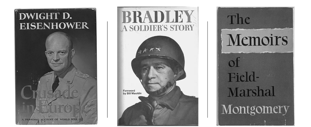
Dan Weavers
University of Exeter
In 1948, US General Dwight D. Eisenhower published his memoir of the Second World War, Crusade in Europe, starting a war of words between American and British allies. Eisenhower’s criticism of Field Marshal Bernard Montgomery in particular produced a wave of indignation in a weakened and declining Britain, whose policymakers were hoping to exchange the moral capital earned from contribution to victory in the war against Nazism to reestablish their global standing and maintain the Empire and Commonwealth.
The symbolic capital of “Monty” was a key source of moral capital for the nation: to insult Monty was to insult Britain. The situation was compounded by the publication of US General Omar Bradley’s A Soldier’s Story in 1951, which presented an escalation in these criticism of Britain’s favourite soldier, just as both countries were once again fighting alongside each other in Korea. Therefore, Eisenhower’s and Bradley’s words were deemed by some in the UK as potentially harmful to the Anglo-American Special Relationship, whilst Britain was desperate for continued American support for British postwar revival.
Britain’s fall from the top rank was reviled not just by the political figures of the day, but also the British military men of the war. Montgomery was not only possessed of vast egotism and self-centredness which fuelled his rage at his former American colleague’s books; he was “always alert to the diminution of British power and influence, and the shrinking of the British Empire distressed him.”[1] He waited until 1958 to publish the vengeful Memoirs, in the aftermath of now President Eisenhower’s repudiation of the British over Suez. As Niall Barr has stated, the “claims and counter-claims” of their memoirs “had the effect of placing in the spotlight the personalities and relationship of Eisenhower and Montgomery almost to the exclusion of every other issue.”[2]
A dedicated study of the commander memoirs of World War II has not yet been made, an indication of how historians have largely discarded them as biased, distorted and unreliable.[3] Frances Houghton’s The Veteran’s Tale (2018) expertly examines the memoirs of the common British soldier but is not a study that encompasses commander books. When viewed through the prism of the Cold War, rather than the Second World War, a whole new perspective of these memoirs can be viewed. Therefore, whilst memoirs have often been dismissed as being of very little value historically, those of the Second World War commanders in fact offer a fascinating window into British postwar imperial anxieties.
Continue reading “Ike, Brad & Monty: Memoirs and Britain’s Postwar Decline”
Mitchel Stuffers
Assistant Editor at CIGH Exeter & PhD Candidate in History, University of Exeter

Mitchel Stuffers
Assistant Editor at CIGH Exeter & PhD Candidate in History, University of Exeter
Mitchel Stuffers
Assistant Editor at CIGH Exeter & PhD Candidate in History, University of Exeter

Mitchel Stuffers
Assistant Editor at CIGH Exeter & PhD Candidate in History, University of Exeter

Mitchel Stuffers
Assistant Editor at CIGH Exeter & PhD Candidate in History, University of Exeter
Mitchel Stuffers
Assistant Editor at CIGH Exeter & PhD Candidate in History, University of Exeter


You must be logged in to post a comment.