
Editor’s Note: In the weeks leading up to the new year, please help us remember 2018 at the Imperial & Global Forum by checking out the past year’s 10 most popular posts.
Marc-William Palen
History Department, University of Exeter
Follow on Twitter @MWPalen
In case you missed it (I was tweeting about it A LOT last week), Cornell Library’s Digital Collections have just made available an amazing archive – the PJ Mode Collection – consisting of around 800 political maps that should be on the radar of anyone working on imperial and global history. They. Are. Awesome.
Here’s a sampling.
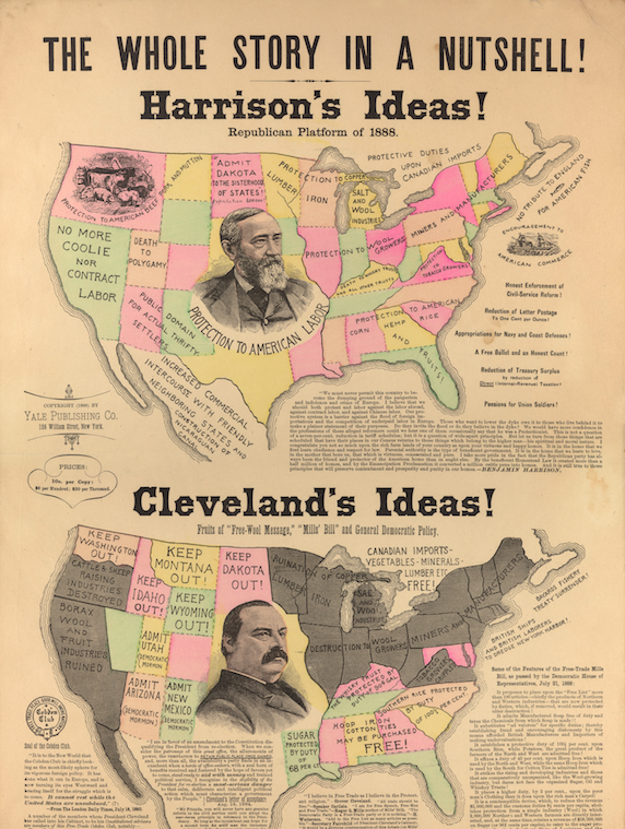
‘The Whole Story in a Nutshell!’ (1888) – Here’s one of my favorites for a lot of reasons. To give it some context, the so-called Great Debate of 1888 (that year’s presidential election) was centered around the future of US trade policy. The GOP was staunchly protectionist and Anglophobic at this time, and they feared the perceived influence of ‘Free Trade England’ on US politics. British free traders (in particular London’s Cobden Club, featured on the bottom left), were the main targets of paranoid Republican protectionist propaganda. Democratic President Grover Cleveland only added to the conspiracy theories when he filled his cabinet and advisors with US members of the Cobden Club. The pro-Harrison map does a vivid job of illustrating the GOP’s economic nationalism in contrast to Democratic free trade. For more on this, my book, The ‘Conspiracy’ of Free Trade, explores the conspiratorial reception of British free-trade ideas in Gilded Age America.

You must be logged in to post a comment.